UAE Insurers Turn To Satellite AI As Risk Pricing Gets More Personal
UAE insurers are testing satellite imagery and AI for property, flood, fire, and climate risk assessment. Supporters expect faster claims and wider coverage, while analysts warn about privacy, bias, and affordability risks. The next test is whether insurers can make AI-based pricing explainable, auditable, and acceptable to customers and regulators.
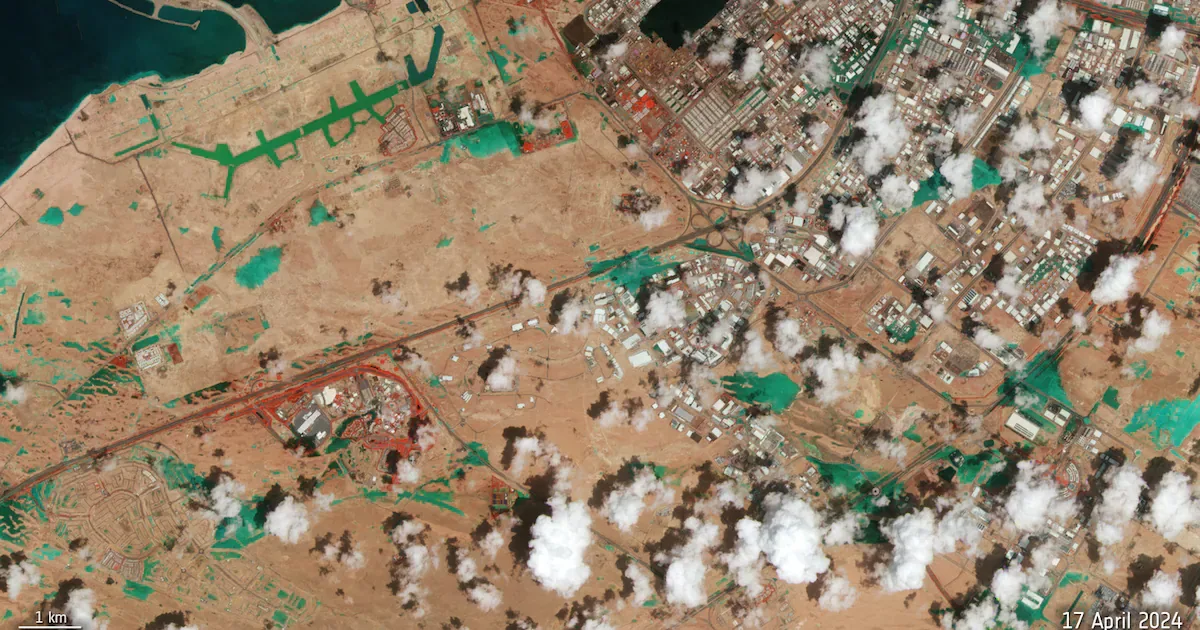
UAE insurers are moving satellite imagery and artificial intelligence closer to underwriting, claims handling, and climate-risk pricing.
The shift could make cover faster and more tailored, but it also raises a sharper customer question: whether better risk visibility will produce fairer insurance or more selective access.
The Infrastructure Signal
The model combines geospatial data, high-resolution images, and AI systems that can evaluate buildings, neighborhoods, flood paths, and other physical risk indicators.
In the UAE, the issue has become more immediate after the April 2024 floods showed how quickly weather events can affect homes, vehicles, and commercial assets.
Shory, a UAE digital insurance platform, has been developing internal AI models and has explored satellite-imaging cooperation with Orbitworks, the Abu Dhabi space and defense manufacturer.
The wider ecosystem also includes geospatial providers and Space42, the Abu Dhabi company created through the Bayanat and Al Yah Satellite merger.
Pricing Gets More Granular
For insurers, the commercial attraction is clearer risk selection.
Satellite and aerial data can help underwriters move beyond questionnaires, photos, postcodes, and claims histories toward more current views of the insured asset and its surroundings.
Remote assessment may shorten claims processing, with straightforward claims potentially settled within days.
That precision does not automatically mean cheaper cover.
IDC expects AI and satellite-based climate products to become more common globally by 2029, especially in climate-exposed areas.
More granular models can shift insurance away from pooled averages toward pricing that changes by location, asset condition, and real-time exposure.
Consumer Risk And Regulatory Pressure
The same systems that improve underwriting can make insurance harder to explain.
Experts cited by The National warn that satellite intelligence could support premium increases, declined coverage, or redlining-like outcomes if vulnerable locations are treated as unacceptable risks.
Privacy concerns also rise when monitoring becomes continuous rather than a one-time inspection.
Regulators are likely to focus on whether the models are explainable and tested for bias.
That matters in the UAE because insurers are expanding data use while expectations around consumer rights and automated decisions are tightening.
Strategic Watchpoints
The first watchpoint is governance.
Insurers will need clear audit trails showing how satellite and AI inputs influence quotes, exclusions, claims decisions, and renewals.
The second is customer trust.
Faster claims and fraud reduction could benefit policyholders, but only if pricing logic is understandable and appeals are available.
The third is partnership strategy, because many insurers may rely on insurtech and geospatial vendors instead of building satellite infrastructure themselves.
For the UAE market, satellite AI is becoming part of how insurers see risk, price uncertainty, and decide who receives cover.
Summary version for Medium
UAE Insurers Turn To Satellite AI As Risk Pricing Gets More Personal
What the announcement means beyond the headline
Quick Summary: UAE insurers are testing satellite imagery and AI for property, flood, fire, and climate risk assessment. Supporters expect faster claims and wider coverage, while analysts warn about privacy, bias, and affordability risks.
The Infrastructure Signal
The model combines geospatial data, high-resolution images, and AI systems that can evaluate buildings, neighborhoods, flood paths, and other physical risk indicators. In the UAE, the issue has become more immediate after the April 2024 floods showed how quickly weather events can affect homes, vehicles, and commercial assets.
Pricing Gets More Granular
For insurers, the commercial attraction is clearer risk selection.
- Point 1: The central topic is UAE insurance, with the announcement framed around concrete operating detail.
- Point 2: Satellite and aerial data can help underwriters move beyond questionnaires, photos, postcodes, and claims histories toward more current views of the insured asset and its...
The important shift is not the AI label, but the operating boundary it creates for teams.
Consumer Risk And Regulatory Pressure
The same systems that improve underwriting can make insurance harder to explain. Experts cited by The National warn that satellite intelligence could support premium increases, declined coverage, or redlining-like outcomes if vulnerable locations are treated as unacceptable risks.
Read the Full Deep Dive
Want to explore the complete technical analysis, enterprise trade-offs, and detailed metrics?
Read the full article originally published at SendTech Times